- Web
- Humsa
- Videos
- Forum
- Q2A


- Home
- News
-
Featured News
-
- Articles
- Videos
- Connect
- Sawal aur Jawab
- Translation
- SMS
- Games
-
Latest Games
 Redneck Shoot-Out
Eliminate all redneck by shooting them. Complete 3 levels of…
Redneck Shoot-Out
Eliminate all redneck by shooting them. Complete 3 levels of…
 Flash Chess 3D
3D Flash Chess with great AI opponent
Flash Chess 3D
3D Flash Chess with great AI opponent
 Tic Tac Toe
 - the classic
Tic Tac Toe
Tic Tac Toe - the classic
 Element Saga ep1-4
Use techniques such as sword strike, fireball and combos to …
Element Saga ep1-4
Use techniques such as sword strike, fireball and combos to …
 Megaman Polarity
Platform fighting game using Megaman as characters!
Megaman Polarity
Platform fighting game using Megaman as characters!
 Blast Billiards
In this billiard game, you have limited time to pocket all t…
Popular Games
Blast Billiards
In this billiard game, you have limited time to pocket all t…
Popular Games
-


 Clean Chit (Faisal Raza Abidi ...
  Akhir Kiyon - 16th December 2...
  To The Point - 16th December ...
  Capital Talk â
  Kal Tak - 16th December 2013
  Bay Laag - 16th December 2013
  Kharra Sach - 16th December 2...
  Awaam - 15th December 2013
  Gold Miner
  Superbike GP
  Whipsaw Fighter
  PacMan
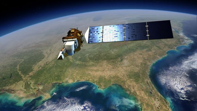
When NASA's Landsat Data Continuity Mission (LDCM) launches on Monday, it will deliver to orbit the latest and most capable Earth-observing satellite in a four-decade long project to study the surface of our planet.
Examining Earth at a resolution of a quarter of an acre, the Landsat satellites have enabled a better understanding of deforestation, glacial retreat, the shrinking Antarctic ice sheet, increasing wildfires and other big changes taking place across the planet.
"All of these changes are occurring at rates unprecedented in human history due to an increasing population," LDCM project scientist Jim Irons, of NASA's Goddard Space Flight Center in Greenbelt, Md., said during a press conference Friday (Feb 8).
"We will be able to continue monitoring these changes from the best Landsat satellite ever launched," he added.A forty-year projectWhen astronauts first left the surface of the Earth in the 1960s, some of their first science objectives involved mapping the planet's surface. But such mapping, linked to human exploration of space, came in starts and stops, failing to provide consistent data.
The Landsat program, a joint effort of NASA and the United States Geological Survey (USGS), changed all that.Originally called the Earth Resources Technology Satellites Program when it was proposed in 1966, Landsat officially received the green light in 1970 and first reached orbit with Landsat 1 in 1972.Each new satellite has overlapped with its predecessor, sometimes for years. Landsat 7, launched in 1999, still functions in limited capacity,
The LDCM spacecraft — set to blast off Monday at 1:02 p.m. EST (1802 GMT/10:02 a.m. PST) from Vandenberg Air Force Base in California — will be the eighth satellite in the program.It will be renamed Landsat 8 after launch and a series of on-orbit checkouts. The USGS will take over operation of the spacecraft at that point, about three months after liftoff.Orbiting the Earth every 90 minutes, the Landsat satellites image the entire planet over the course of 16 days. When two work together, changes on the surface are captured every eight days.
Although the technology behind the satellites has improved, the programs manage enough consistency that data from the newest satellite is easily comparable to data from the original.Each Landsat pixel measures 98 feet on a side, capturing enough detail for scientists to glean a great deal of information about environmental change and surface processes.
In 2009, the possibilities for Landsat data grew significantly when the entire image library was placed on the Internet for anyone to use free of charge. The archived data, which is managed by the USGS, is the longest continuous record of Earth's land surface as seen from space."The Landsat data plays a critical role in enabling scientific inquiry," said Mike Wulder of the Canadian Forest Service in Victoria, British Columbia. "Over time, the systematic collection and archiving of imagery since the inception of the Landsat program has enabled sophisticated scientific analysis to be taken."
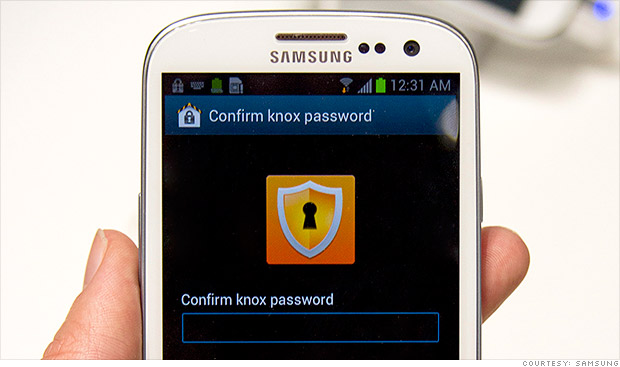 Having already stolen the consumer crown from Apple's iPhone, Samsung is looking to supplant BlackBerry in the business world.
To get corporate IT departments -- BlackBerry's (BBRY) last remaining stronghold -- to consider opening their gates to other mobile devices, Samsung will be padlocking its upcoming Galaxy S4 smartphone with a security solution app..... Read more
Having already stolen the consumer crown from Apple's iPhone, Samsung is looking to supplant BlackBerry in the business world.
To get corporate IT departments -- BlackBerry's (BBRY) last remaining stronghold -- to consider opening their gates to other mobile devices, Samsung will be padlocking its upcoming Galaxy S4 smartphone with a security solution app..... Read more
 Struggling smartphone maker BlackBerry said Friday it was suing a company founded by TV’s Ryan Seacrest over a slip-on keyboard accessory for the iPhone that offers BlackBerry-like functionality to the Apple gadget.
Typo Products LLC, founded by entrepreneur Laurence Hallier and media personality Seacrest, said that their first accessory, the Typ..... Read more
Struggling smartphone maker BlackBerry said Friday it was suing a company founded by TV’s Ryan Seacrest over a slip-on keyboard accessory for the iPhone that offers BlackBerry-like functionality to the Apple gadget.
Typo Products LLC, founded by entrepreneur Laurence Hallier and media personality Seacrest, said that their first accessory, the Typ..... Read more
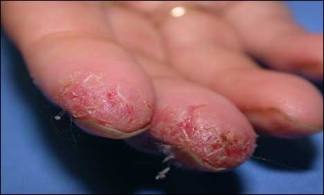 Adults with excessively dry hands were four times more likely than healthy counterparts to fail computerized fingerprint verification tests in a small new study from Malaysia.
"Because of the emerging use of biometrics in daily living, I think hand dermatitis is an upcoming problem," said lead author Dr. Lee Chew Kek, a dermatologist ..... Read more
Adults with excessively dry hands were four times more likely than healthy counterparts to fail computerized fingerprint verification tests in a small new study from Malaysia.
"Because of the emerging use of biometrics in daily living, I think hand dermatitis is an upcoming problem," said lead author Dr. Lee Chew Kek, a dermatologist ..... Read more